IDEN
News Detail
BRIN Explains Lanslide in Indonesia Has Very High Frequency
Published on April 25, 2024
Jakarta-BRIN Public Relations. By 2024, landslides in Indonesia have a very high frequency, as of April 2024, there have been 183 incidents. According to Indonesian disaster data and information sources BNPB indicates, landslide has the highest frequencies compared to other natural disasters, such as floods, abrasions, windstorms, earthquakes, and so on.
According to the data recorded by the BNPB also in the last 10 years exactly 2015-2024, the landslides are very high incidence of which reaches 7024 incidents. This indicates that it is a very important natural disaster to study, so that its impact can be minimized in later days.
The statement was submitted by Sukristiyanti of the National Research and Innovation Agency (BRIN) Research Center for Geological Disaster at a webinar on Dissemination and Utilization of Regional Research & Innovation on the topic of Satellite Image Data Utilization for Response Management in the Region, Wednesday (24/03).
"Landslide is the movement of masses of rocks, debris, or soil down a slope due to gravity. Landslide is generally an isolated process, which individually is not very large in size, but often occurs in a region," she said.
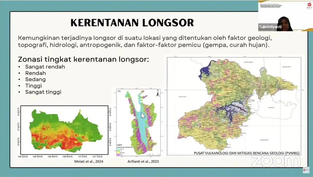
She adds, to the vulnerability of the slide the possibility of occurrence at a location determined by geological, topographic, hydrological, anthropogenic factors. It is triggered by other factors like earthquakes and rains. While the zoning of the vulnerability level of the slide covers very low, low, moderate, high, and very high.
"For this catastrophe, we can use satellite image data using the Google Engine (GE) and the Google Earth Engine (GEE). GE is a non-paid platform, with high spatial resolution and timeseries. It has a lot of data sources, timeseries, and can do slide vulnerability modelling based on machine learning," she said.
The development of remote sensing technology according to M. Rokhis Khomarudin Acting Head of the Research Center for Geoinformatics (Pusat Riset Geoinformatika/PRG) of BRIN has been so fast. Now there is a lot of satellite remote sensing data that photographs the Earth's surface, and can be widely used by society at large.
"Now a lot of satellite data with very high spatial resolution, like houses already visible, can detect some important objects that used to be only be able to be captured by aerial photographs. Through satellites we can detect areas with high space resolution," he said.
It is also surprising, the data availability is now huge, and there are some providers that provide free data on google, such as USGS Earth Explorer, landviewer, Copernicus data hub, sentinel hub, and others.
"Around 1990 an data that was paid, now it is free with worldwide coverage and can be downloaded. Having a good historical, from 1980 such data already exists. So far it is still available on the web, mainly on the USGS Earth Explorer and Landviewer. There are also several platforms that have been developed such as Google Earth Engine, SEPAL and GEP, and we can use it for free and free data processing," he added.
Furthermore, Rokhis exposes the role of remote sensing data to the advancement of disaster management that can detect before events by performing early warning systems. Detect changes in land coverage, do hazard mapping, and vulnerability of an area to disasters.
"When a disaster occurs, we can monitor where the disaster occurred. Then what the impact is, one example is related to land and forest fires. After it happens we can see the impact of that disaster, where the sites are damaged, and so on," he said.
For geological disasters, it is rather difficult to create an early warning system, whereas for hydrometeorology, one of the tips is to make early warnings on a regular basis.
"So we can see how the season is, for example this year La Nina potential floods, for El Nino there will be potential droughts and fires, and so on. So the season we have detected, has been aware, and has been predicted by BMKG (Meteorological, Climatological, and Geophysical Agency)," he said.
Seasonal disasters can also occur six months earlier, or a year earlier, as predicted by BMKG. Whether this week have a lot of rainfall or not, means a warning for flooding.
When there is no rain after a week, it is a warning against drought and fire in the land and forest. "In addition, there is a daily early warning. Even for the flood areas, some areas have been installed telemetry and monitoring systems from top to bottom," he said.
Meanwhile, Deputy Chairman for Regional Research and Innovation (Riset dan Inovasi Daerah/RID) of BRIN in his greeting said, this webinar will focus on the material utilization of satellite image data to seize disaster in the region. He hoped to increase one of the reception or awareness of the public in using satellite image data to defuse this disaster.
"BRIN is the only government agency that has authority for the acquisition and distribution of satellite image data. BRIN is also the agency responsible for the procurement, processing, and management of remote sensing data for national needs. We provide services to all kinds of parties who need satellite image data," he added.
It displays, based on data on satellite imaging services carried out by BRIN in 2023-2024 by sector specifically for publishers, as the largest user of satellite image services compared to other users.
"Of the 281 requests for satellite image data services from the manufacturers, it is predominantly specifically for space mapping or for agriculture and plantation. While the potential for disasters in Indonesia is large enough, we hope that one of the important information satellite image data can be used to mitigate disaster management,” he hoped. (ns/translator:akb)